A Travelogue for Brie and Gabi
A Journey with Uncle Dave and Aunt Nette
Dear Brie and Gabi,
I hope you like to look at maps. To me, they are very interesting. There is a website that lets people watch the progress of airplane flights. It’s called FlightAware. I’m watching Uncle Dave and Aunt Nette’s airplane flight today. I know you were at camp today and your Mom and Dad were working, so I made a travelogue for you to show you the route their plane took from Naples to New Jersey. I hope it’s fun for you to read.
If you can read this on a computer, you’ll be able to see the maps in color. That’s much nicer than seeing them in black and white.
When I started, I was messaging on the phone. Your mom was working, and I didn’t know it would be so distracting to keep messaging, so when she asked me, I switched to this document and actually it’s a lot more interesting this way. I hope you like geography! The plane crossed over many countries, and you can read it all here.
If you can open Google Maps on your computer, you can see the whole route and see the countries the plane passed over, starting in Italy, going through Europe, crossing over Great Britain (England) and Ireland (Ireland and Northern Ireland), passing by Iceland and Greenland, then Canada, and then into the United States. I hope it’s as much fun for you as it is for me!
Here’s where we started: The plane left the gate in Naples to taxi to the runway 5 minutes early, at 8:00 our time. It was 2:00 in the afternoon in Naples. It took a while to take off. The pilot has to wait for the go-ahead from flight control before they can speed down the runway and take off into the sky. At 8:39, the plane took off!
The plane flew north from Naples and crossed over into France at 9:46. At 10:08 it passed Lyon, France. I took a journey on Google maps into Lyon and it is a fascinating small city. It looks like a place I would enjoy visiting! I’ll bet your Great Uncle Albie and Great Aunt Helen visited Lyon when they lived in France.
By 10:35, the plane was passing to the east of Paris. Paris is the Capital City of France and is one of the major cities in the world.
At 10:48, they were crossing over the English Channel. The plane was moving fast and entered Great Britain around the town of Folkestone, which is on the Southeast Coast of Great Britain, or England. Their route took them past London, the Capital City of England, and over a town called Wickford.
Travelogue continued
We left off over Northern Ireland. When the plane crosses past Northern Ireland, there is still some Ireland before the ocean. The plane crosses over County Donegal. County Donegal is famous for its Irish Music and songs. At 11:54, crossing into Ireland over Londenderry.
The program jumped ahead, and at 11:56 plane is now over the North Atlantic Ocean! Sometimes the feed at flightaware.com gets a little behind where the plane has advanced to. Then the data arrives and the track of the plane jumps ahead.
Now for the long trip over the ocean.
At 12:24, crossing south of Iceland! Plane is shifting course slightly southward.
At 12:32, still south of Iceland, but above Iceland is the Eastern Coast of Greenland! There is a little town on the East Coast called Ittoqqortoormiit. How about that for a name! On Google Earth, you can’t get down to the roads there, but it is a simple small community. What would you imagine people would do for a living there? How remote and isolated is it? Just south of this community, there is a Bay called the Greenland Sea. There are two small towns there, too; one near Ittoqqortoormiit and the other around on the Bay side.
On the flightaware map, there is an arc showing the trajectory of the plane route over the ocean, which is shown in addition to the actual course of the plane. Here, south of Iceland and Greenland, the pilot is setting his course in a straight line under the arc. How does that affect the distance of the route? I’ll draw it here so that the question makes more sense:

… but, whoops!! All of a sudden, the plane turned northward. On the radar map, clouds are seen ahead, and maybe the pilot is changing course to avoid a storm. How do clouds show up on a radar map?
Answer: They look like this:
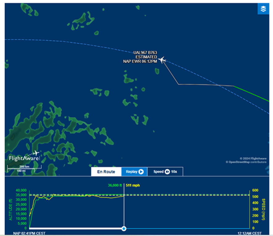
This Word document won’t print out in color, but if you are reading this on your computer the color will show up. You can see the arc and the line that tracks the plane route. You can also see the little white plane! The ocean is dark blue. The clouds show up as green blobs in color, but printing is black and white. Can you see them? That could represent a storm. Even though the airplane is flying at 36,000 feet at this point, it might still be affected by the storm and winds. It is flying at 511 miles per hour (mph) at this point.
And now, and 1:00 our time, the flight is at the halfway point!!
Now, it’s 1:19 and the plane is still south of Greenland. Here is a screen shot of the plane over the ocean:
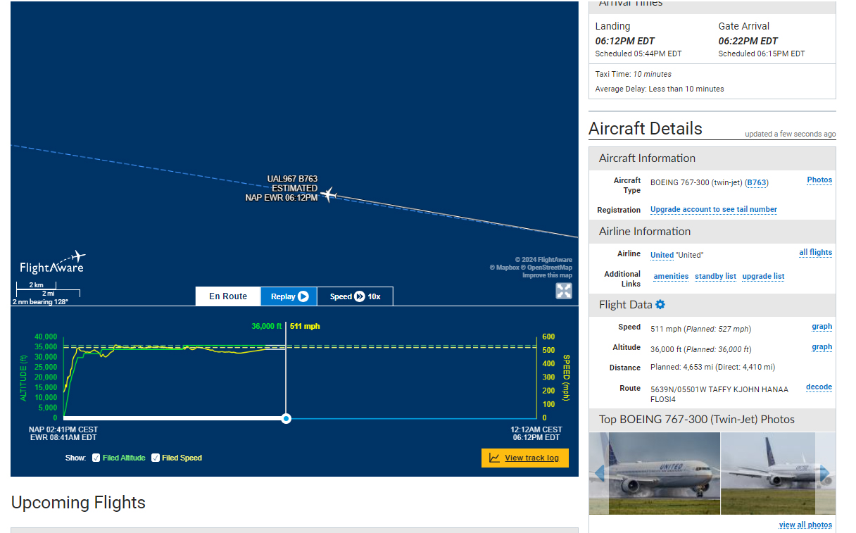
When the plane is south of Greenland, on the East Coast there is a town called Sermiligaaq. If you can find it on Google Maps and zoom in on it, you can see there are just a bunch of little homes and a few bigger buildings including a church. The landscape is very barren and rocky. See if you can open some of the pictures. What do you think it would be like to live there?
While it seemed like the plane was going so fast when it traveled over Europe, here in the midst of the ocean it seems to travel very slowly. It’s almost 2:00 and the plane still seems to be hovering under Greenland. I hope this means that Uncle Dave and Aunt Nette are taking naps! When they were in Italy, it was 8:00 at night there. When they land after 6:00 our time, it will be midnight in Italy.
According to Flightaware, the plane is expected to land in Newark, New Jersey at 6:12 p.m. The good part of that is that their flight has only 4 hours to go. When we reach the coast of Newfoundland and Labrador, it will get more interesting again.
At 2:16 p.m., the plane is approaching the west coast of Greenland. Greenland is part of the Kingdom of Denmark, but the country governs itself. Most of the towns in Greenland are on the southwest coast. Some of the towns are Nanortalik, Norsarmijit, and Aappilattoq. According to a quote from Wikipedia about Aappilattoq, it “is a village in the Kujalleq municipality in southern Greenland. The name means “red” in the Greenlandic language, named after the red mountain rising above the settlement. The settlement had 100 inhabitants in 2020.” That’s a small town! Here’s a picture of Aappilattoq:

If you can look at Google Maps on your computer, can you find these towns? They are near the coast in the south of Greenland. Here is a link to Google Maps: https://www.google.com/maps/
Brie and Gabi, it’s 2:50 now, and, on the chart, the plane has finally passed Greenland! Hooray!!
We’ll all be so happy when Uncle Dave and Aunt Nette are back home. They’ve had a very difficult time in Italy.
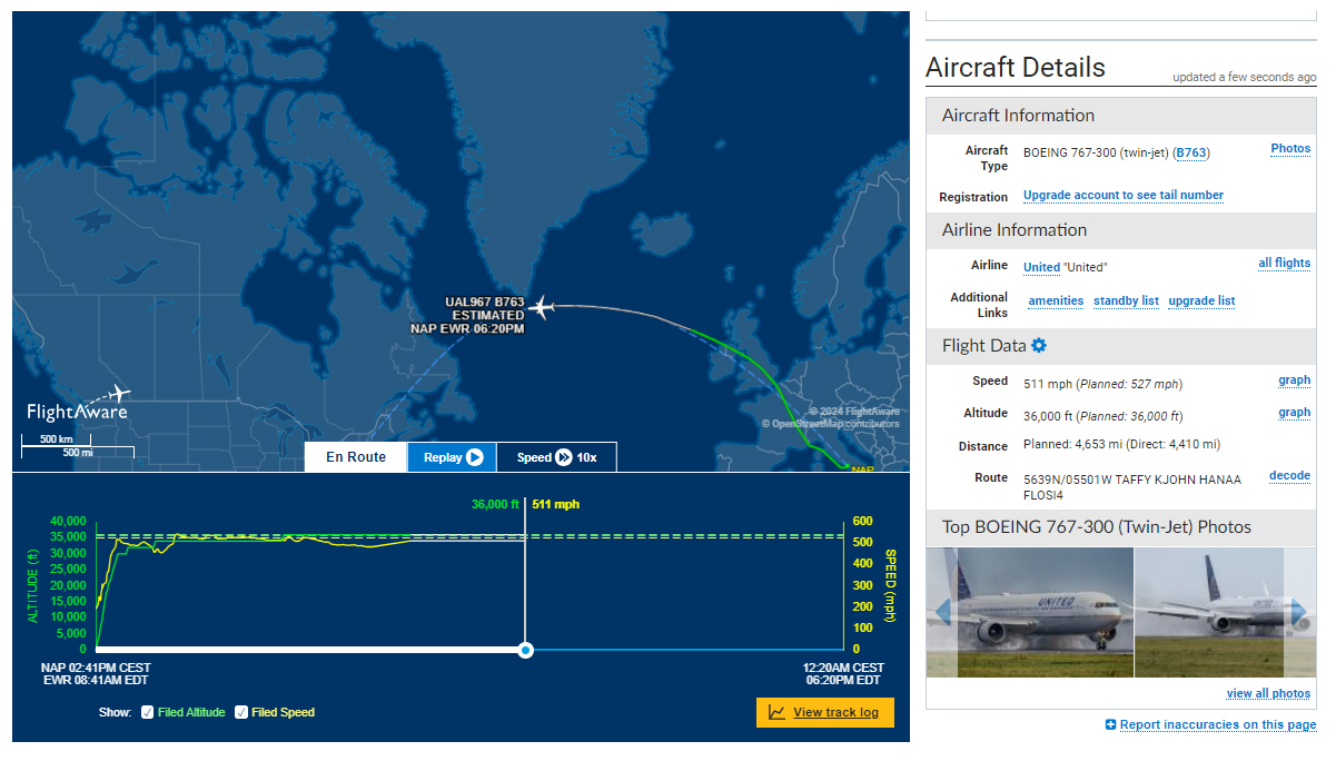
When the plane was under Greenland, it seemed to stay there for a really long time. Here it is at 3:00:
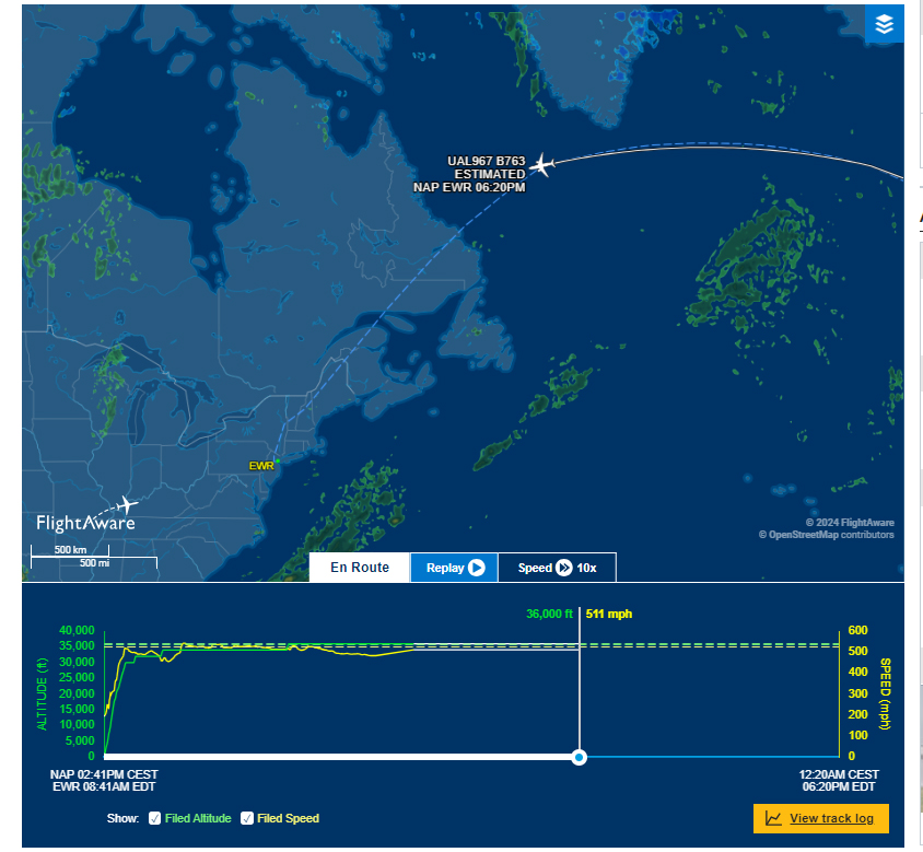
Guess what Countries come next? Hint: The answer is in the text above 😊
Pretty soon the plane is going to arrive at Newfoundland and Labrador. It will arrive over the Labrador Inuit land. The Inuit are a Native people. The coast has towns, or named areas, but there don’t seem to be any houses or people living there on the coast.
If Uncle Dave and Aunt Nette can see out of the airplane window, or if they are awake, very soon they’ll see something other than vast ocean all around. It’s common for people to take naps while they are flying in an airplane, except if they are pilots or attendants … 🙂
It’s 3:47, and the plane is finally over Newfoundland/Labrador!! The nearest towns are Holton and Lucyville, but there’s no sign on Google Maps of any houses there. The Eastern Coast faces a part of the Atlantic Ocean called the Labrador Sea. Because it’s near the warm currents of the ocean, the climate is not as harsh as one would expect. The summers are cool to warm.
Uncle Dave and Aunt Nette are on the final leg of their flight!
When the plane passes out of Newfoundland/Labrador, it will be over Quebec, Canada! Then it will pass over a part of New Brunswick, Canada. Canada does not have states like the United States does; they are Provinces. What country comes after Canada? What state do you think they will pass over next? Take a guess and tell me what you guessed!
Hint: Here’s a screenshot now:
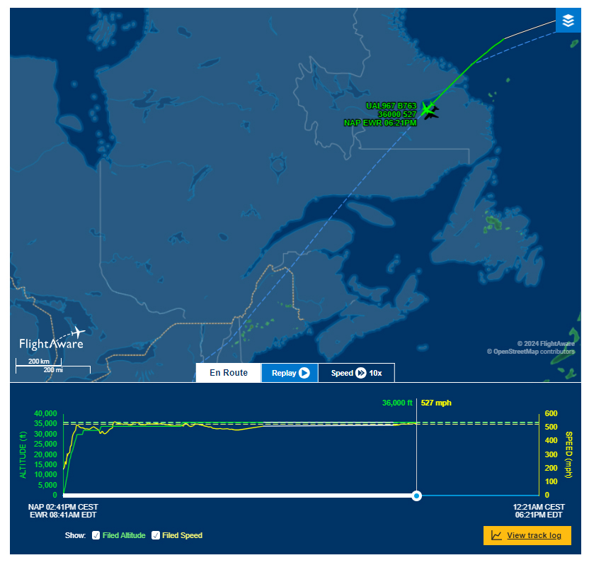
The plane is going very fast now. It’s going 531 mph now and in this picture it was going 527 miles an hour!
It’s 4:12, and the plane is now over Quebec, Canada. You know how we say Quebec kwe-beck? Well, the people who live in Quebec say it a little differently. When they say it, it sounds like ke-beck. Try it and see how it sounds different.
It’s 4:30 now, and the plane is passing over Chaleur Bay in Quebec, Canada. After Chaleur Bay, it will be crossing over New Brunswick.
At 4:50, the plane has just crossed over the Bay and is now over New Brunswick, Canada. In a short while, the plane will be in another country. Did you figure out what comes after New Brunswick?
Look!! They are almost home!!
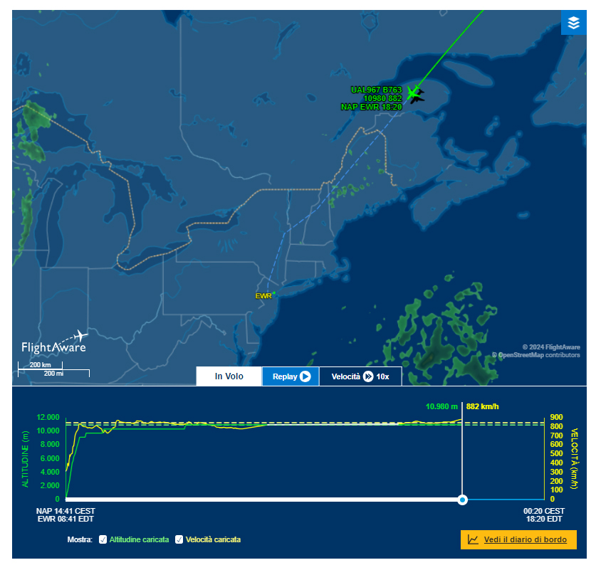
The answer: MAINE!!
When the plane crosses into the United States, it will be near Grand Isle, Maine. Here’s another blurb from Wikipedia: “Grand Isle is a town in Aroostook County, Maine, United States. The population was 366 at the 2020 census. The village of Grand Isle is in the northwestern part of the town.” That’s a small town, too, and right at the tip of Maine across the St. John River, which separates Canada from the United States there.
It’s 5:10 and the plane just crossed into the United States in the State of Maine!! Hooray!!
Then the plane crossed into New Hampshire. It’s very rural and all forest in the northeastern part of New Hampshire where the plane passed through. There are not many towns there, but it seems to be entering New Hampshire around the Cambridge area.
After New Hampshire comes Vermont. We love Vermont!! The plane entered Vermont at 5:39 right around the town of Barnet, Vermont. It crossed the state and entered the State of New York at 5:46 just above Saratoga Springs, where your Mom’s cousin Elizabeth works now, at Skidmore College where she’s a Vice President. There’s not far to go now!!
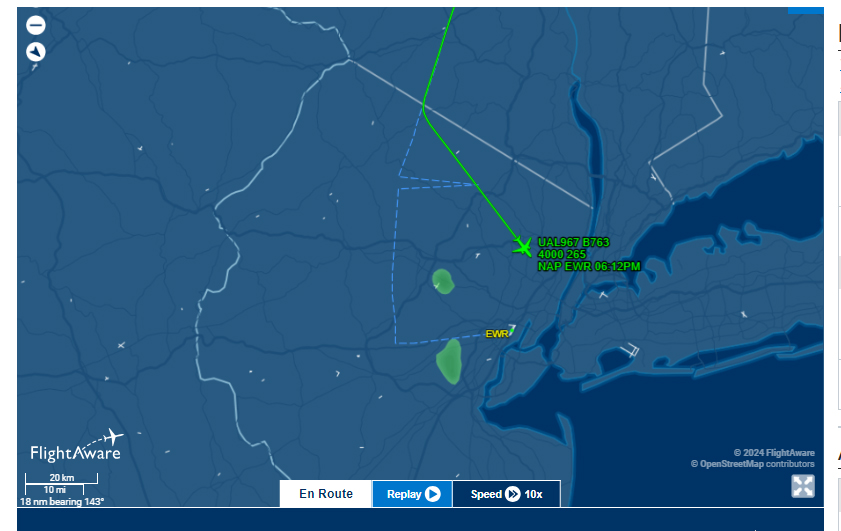
In New York, the plane has slowed way down. It’s going about 450 mph now. The pilot will have to coordinate with the airport for clearance to land, so the pilot has to get the plane to the airport with good timing.
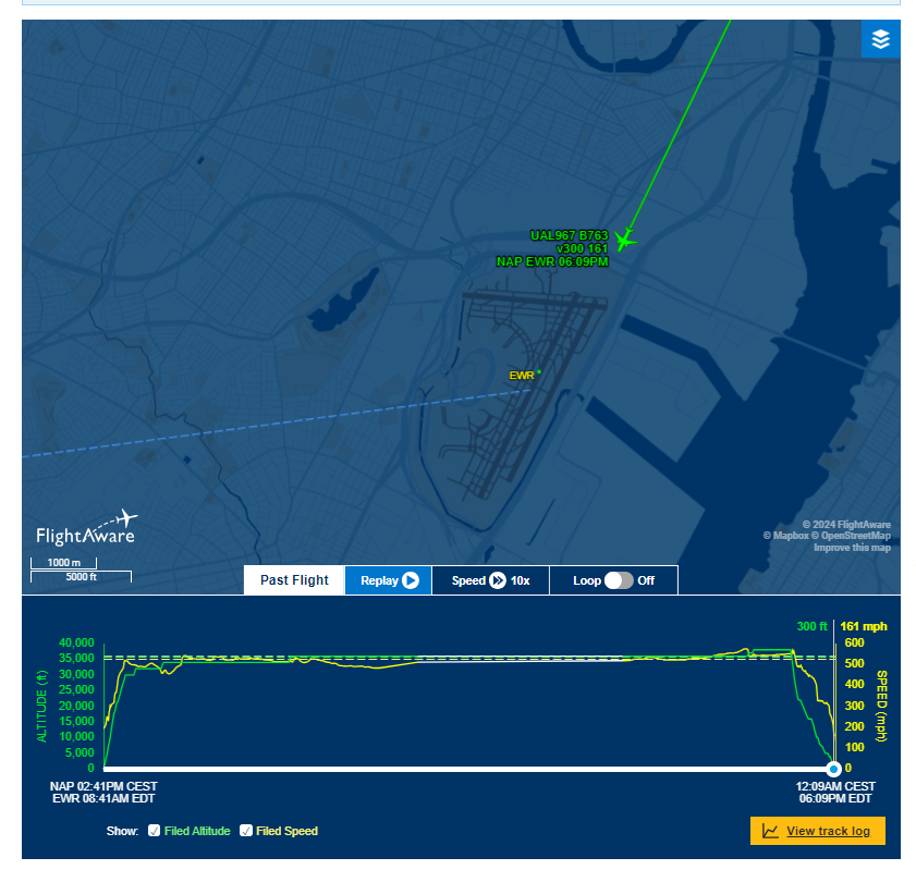
Two more pictures before the plane lands. They will land at Newark Airport; that’s EWR on the map. Uncle Dave has his car parked at the airport. Hopefully, the airline will help Aunt Nette get to the car. In Naples, Aunt Nette had help getting to the plane, also.
The plane landed at 6:19. Whew!! Thanks for reading this journey!!
Love to you, Brie and Gabi,
Grammy